
By Bob Morrow, Montana NMA member.
Have you ever had a case where the cop said you were going 45 in a 35 zone as he hands you the ticket, but you know you were going 35?
How do you prove that?
Telling the judge “I was only going 35, honestly, your Honor” will get you laughed out of the courtroom. Pay the clerk on your way out. Next!
You may be able to prove it with your GPS unit. If you leave your Garmin GPS unit turned on (this article refers only to Garmin units because that’s what I have, other manufacturers’ devices may or may not work this way), it is tracking your location, speed and altitude.
It is doing this whenever the unit is turned on; you don’t have to do a thing other than download it to your computer. As far as I know, you can’t turn this feature off.
You can do this on your laptop in the courtroom in front of everyone. (Of course, the old courtroom adage of not asking a question you don’t know the answer to applies. Only present the GPS data as evidence if you are convinced it will help your case.
With a free program called Google Earth, you can see all of that data, and better yet, print it and show it to the judge.
While this article refers to version 6 of the program; it may work on older versions as well.
Go out for a short ride around town with the Garmin turned on. Then come home and connect it to your computer with a USB cable.
If you’ve never done this before, connect it and wait a bit so that Windows can recognize it.
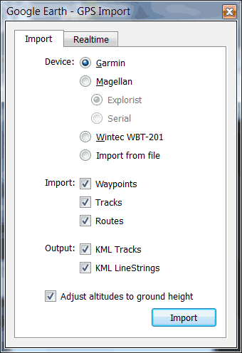
Start Google Earth and go to Tools/GPS. Set it up like this, then click on Import:
It then shows you the map, plus all the favorites you have saved. In the upper left corner is a timeline. You can move the slider to the right to eliminate older information.

Zoom in on the map. Look for the blue lines. These indicate routes you’ve traveled.
Click on the arrows and a balloon pops up with all the relevant information. The arrows indicate the direction of travel. Yes, your GPS has enough resolution to see which lane of the interstate you’re in.
In this case, you can see I was on both the northbound and southbound lanes of Interstate 15. For the record, I was not driving on the grass to the right of the balloon (where you can see a loop).
There was a loop at one time, but it is now a normal ramp on to the interstate. The satellite pictures that Google Earth uses are a few years old. (That plus my Ford E-150 cargo van isn’t very good off-road.)
The time format shown in the balloon is year-month-date, hour:minute:second (in 24 hour format). “Z” refers to the Zulu time zone, otherwise known as UTC or Coordinated Universal Time, which does not have daylight savings time.
So, this event happened on Nov 11, 2011 at 8:58:12 AM local time. Eastern Standard Time is UTC-5, Central is -6, Mountain is -7 and Pacific is -8. (Daylight time is different still; Eastern Daylight Time is UTC-4 for example.)
This is just one of the many things you can do with your GPS that you probably didn’t know about.
A note for parents of teen drivers: this also gives you the ability to know where your kids are going, at what time and speed, all without them knowing about it.
All you need to do is leave the GPS turned on. Just don’t let them see you removing the unit from the car and/or connecting it to your computer…